Air Grid Pro — Stop guessing where your Wi-Fi problems are. Measure them.
Professional wireless coverage analysis for business-critical networks. Air Grid Pro turns walk surveys into measured heat maps, predicted coverage and client-ready reports, for network engineers and IT teams who need evidence, not guesses.
$3,500 Per-device licenseOne-time purchase · no subscription
Wi-Fi decisions backed by measurements
Air Grid Pro records real signal measurements from your Windows laptop's Wi-Fi adapter as you walk a site, places them on your floor plan and turns them into heat maps you can act on.
Use it to validate a new deployment, find dead zones before users do, plan access point placement, and hand customers a report that shows what was measured — and where.
Designed for
Network engineersIT departmentsManaged service providersWireless consultantsCampus and facilities IT
Coverage gaps found after go-live
Survey before and after deployment and compare measured coverage instead of relying on vendor estimates.
Uncertain access point placement
Model predicted coverage from detected, placed or planned access points with walls drawn by material.
No evidence for stakeholders
Export PDF and HTML reports that show measured values, survey points and floor-by-floor results.
Why it matters
When wireless connectivity fails, business operations feel it.
Scanners, tablets, terminals and laptops depend on Wi-Fi that is often only understood after something goes wrong.
Problem
Wireless dead zones disrupt devices and people
Areas of weak coverage are usually discovered by the people who work in them.
Why it matters
Scanner and device disconnections
Interrupted workflows and employee downtime
Recurring support tickets
Wireless that users stop trusting
How Air Grid Pro helps
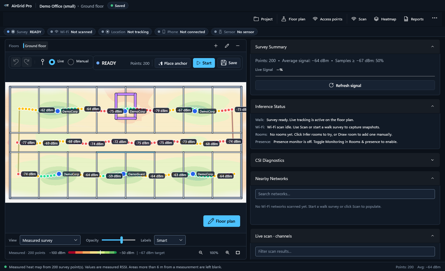
Walk the site and Air Grid Pro records signal measurements at each position on your floor plan, then shows them as a measured heat map with requirement pass/fail and dead-zone views.
Find coverage gaps before they disrupt operations.
Problem
Troubleshooting without data takes time
Without survey information, IT investigates wireless complaints without knowing where coverage is actually weak.
Why it matters
Hours spent chasing intermittent complaints
Changes made without evidence
How Air Grid Pro helps
Measured surveys and visual heat maps show signal strength, signal-to-noise ratio, access point overlap and per-band coverage across the floor, from readings taken where people work.
Visualize your network instead of troubleshooting blind.
Problem
Access points placed by trial and error
Poor access point placement creates coverage gaps and repeated installation changes.
Why it matters
Coverage gaps after installation
Repeat visits to move or add hardware
How Air Grid Pro helps
Predictive coverage models detected, placed or planned access points with walls drawn by material, so you can see the expected effect of a new access point before it goes on the ceiling.
Plan changes with a predicted view of the result.
Problem
Survey work is repeated across sites
IT departments and wireless consultants survey multiple buildings over time and need consistent results.
Why it matters
Inconsistent surveys between sites and visits
Time spent formatting reports
How Air Grid Pro helps
Multi-floor .airgrid projects, PDF and HTML reports, CSV data and map images, and Ekahau .esx import and export, under a perpetual license for one Windows computer.
Reusable professional survey software for every site you work on.
Typical environments
Manufacturing facilities
Warehouses
Distribution centers
Schools
Corporate offices
Network installation contractors
Measurements depend on the Wi-Fi adapter and its driver; Air Grid Pro is not a calibrated spectrum analyzer and does not guarantee compatibility with every device or network.
See Air Grid Pro at work
Five demonstrations recorded from the real Air Grid Pro application on a real facility drawing: a product overview, position tracking during a walkthrough, floor-plan mapping, coverage analysis, and reports and export. Choose a video; nothing downloads until you press play.
Overview1:52Windows
Air Grid Pro product overview
A complete survey in under two minutes: import a building floor plan, set the scale, place the location pin and record the route while Air Grid Pro tracks the position from the pin, steps and heading, then review the measured heat map, the predicted coverage views and the PDF report. Demonstration: no one walked the building; steps and turns were entered with the Step/Turn controls and the Wi-Fi readings are illustrative.
Screen recordings of Air Grid Pro 0.9.0-rc.2 for Windows in demonstration mode, with captions and no audio. The walk was entered with the Step and Turn controls on a laptop that stayed on a desk: no one walked the building, and the Wi-Fi readings are illustrative, not on-site measurements. Position comes from the location pin plus steps and heading; Air Grid Pro does not use GPS or automatic indoor positioning. Coverage views other than the measured heat map are predicted. Names are fictitious; personal names on the drawing are blanked.
Everything a site survey needs
Capabilities of the current release (0.9.0-rc.2).
Measured heat maps
Wall-aware interpolation from your survey points. Areas too far from any measurement are left blank instead of being invented.
Predicted coverage
Model coverage from detected, placed or planned access points before hardware goes on the ceiling.
Manual and live walk surveys
Click to record each measurement, or place a location pin and walk: each step moves your position along your heading (motion sensor and compass on supported devices, or the Step and Turn controls), with placed anchors to correct drift. On a laptop or tablet with a compass the heading follows the device. Windows Location is shown with its accuracy but is coarse indoors (about ±100 m in our tests), so the pin, steps and heading do the positioning.
Native Wi-Fi measurements
RSSI, link quality, channel, band (2.4, 5 and 6 GHz), channel width and BSS load from the Windows Native Wi-Fi API. Estimated values are labelled as estimates.
Floor plans, walls and scale
Import PNG, JPEG, BMP, TIFF or GIF floor plans, set real-world scale and draw walls by material. PDF and CAD drawings import as a preview image.
Access point location estimates
Estimated access point positions with their uncertainty shown.
Multi-floor projects
Survey whole buildings in one .airgrid project, with undo/redo and recovery of interrupted surveys.
Reports and exports
PDF and HTML reports, CSV data, PNG/JPEG images and ZIP project bundles.
Ekahau interoperability
Import and export Ekahau .esx projects.
Screenshots
Actual screens from Air Grid Pro, and from Air Grid Pro Mobile (coming soon to Google Play). Click any image to view it full size.
Technical specifications
Technical specifications
Operating system
Windows 10 version 2004 (build 19041) or later, or Windows 11 — 64-bit (x64)
Runtime
Self-contained installer: .NET and the Windows App SDK are included; no separate runtime installation is needed (verified on a clean Windows 11 PC).
Required hardware
A Windows-compatible Wi-Fi adapter.
Readings depend on the adapter and its driver; Air Grid Pro is not a calibrated spectrum analyzer.
Optional hardware
None required beyond the Wi-Fi adapter. Bluetooth LE is used by the phone companion, which is not yet available.
Floor plan formats
PNG, JPEG, BMP, TIFF, GIF. PDF and CAD drawings import as a preview image.
Projects are stored on your computer. No cloud account is required.
Mobile companion
Air Grid Pro Mobile for Android 8.0 or later (Google Play services required). Sold separately through Google Play.
Licensing
Perpetual license for one Windows computer. Online activation; works offline for up to 30 days between license checks.
Pricing & licensing
One price. Yours to keep.
Air Grid Pro is sold as a perpetual license for one Windows computer. Pay once and keep using it — there is no subscription and nothing renews.
The license is activated online. If you reinstall Windows or replace the computer, release the old installation from your account's Devices page and activate on the new one.
Air Grid Pro Mobile, the optional Android companion app, is a separate annual subscription purchased and managed through Google Play.
$3,500
One-time payment, USD · perpetual license
Per-device license
Perpetual license for one Windows computer
All desktop capabilities listed on this page
Self-service transfer after a reinstall or hardware replacement
Offline use for up to 30 days between license checks
License key and download delivered as soon as payment is confirmed
Secure, encrypted card payment. License issued automatically after payment is confirmed.
Air Grid Pro Mobile
— $100 / year
Annual subscription billed and managed by Google Play.
Google Play listing coming soon
Frequently asked questions
Is Air Grid Pro a subscription?
No. The desktop application is a one-time purchase with a perpetual license. Only the optional Android companion app, Air Grid Pro Mobile, is billed annually — and that is handled entirely by Google Play.
How many computers can I use it on?
One license activates Air Grid Pro on one Windows computer at a time. You can move it to another computer yourself by releasing the old installation on the Devices page of your account.
Does it need an internet connection?
An internet connection is needed to activate the license and at least once every 30 days to re-validate it. Surveys themselves run entirely on your computer.
What do I receive after purchase?
As soon as your payment is confirmed, your license key and the installer download appear in your account under Licenses & downloads, and a receipt with the key is emailed to you.
Are updates included?
Your license is perpetual for the version you purchase and does not expire. Update and maintenance terms are published with each release; if you need specific update commitments, contact us before purchasing and we will confirm them in writing.
Which Wi-Fi adapters are supported?
Any adapter that works with the Windows Native Wi-Fi API. Measurements depend on the adapter and driver, so use the same adapter for surveys you want to compare.
Can I import my existing Ekahau projects?
Yes. Air Grid Pro imports and exports Ekahau .esx project files.
What is your refund policy?
See our refund policy (linked in the site footer) or contact us before purchasing.
Support and downloads
After purchase, your license key and the Air Grid Pro installer are available in your account. Use the Devices page to see where the license is active and to move it after a reinstall or hardware replacement. The installers are signed with our self-signed certificate, so Windows shows "Publisher: Unknown" and SmartScreen may ask you to confirm (More info, then Run anyway); the installation guide explains each step.
Installer download availableAfter payment is confirmed, the installer and your license key appear under Licenses & downloads in your account.